Map or Landmark: Two Ways to Keep a Route Legible
Map or landmark navigation works best when each cue has a clear job: follow the ground in front of you while keeping the route's wider shape in view.
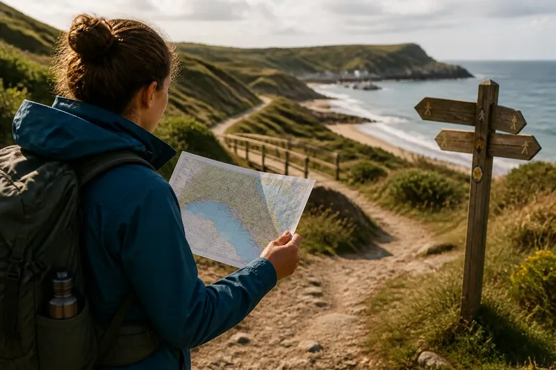
Map or landmark navigation raises a practical question: should you follow the map in your hand or the features you can see ahead? For a simple coastal walk, neither cue needs to do the whole job. A map keeps the route’s wider shape in view; landmarks help you recognize where you are in the moment.
That distinction matters on an easy outing, where the route may seem obvious until a bend, a cluster of dunes, or a path junction looks familiar in more than one direction. The aim is not to choose a winner. It is to give each kind of information a clear role, then check that they still agree.
A map shows how the route fits together
A map compresses a large area into a view you can hold still. It can show the relationship between a trail, a cove, a road, a stream, and the wider shape of the coast. Even when you cannot see the next turn from where you stand, the map may show what lies beyond it.
For a straightforward route, begin by identifying a few features that are both easy to recognize on the map and relevant to your walk. These could be a headland, a path junction, a bridge, or a marked access point. Trace how they relate to one another rather than memorizing a string of turns. If the path curves around a bay, for instance, the map helps you understand why the trail changes direction.
A paper map also gives you a stable reference when your view is limited. Trees, low cloud, tall grasses, or the shape of a dune may hide a feature without changing where you are. An offline map on a phone can provide the same broad picture, but it is sensible to know how to access it without a signal and to carry it in a way that suits the conditions.
Maps have limits. Symbols simplify the ground, and the map may not show every informal track, recent closure, or small change in the path. Its scale can also make two nearby features appear closer than they feel on foot. Treat it as a model of the landscape, not a photograph.
Landmarks make the next choice easier to recognize
A landmark is a visible feature you use to make sense of your position or direction. It might be a distinctive point of land, a footbridge, a large sign, a break in a tree line, or a path that meets the shore. The best landmark is not necessarily dramatic. It is one you can pick out without guessing.
Landmarks work at the scale of the next decision. If you need to stay on a path that bends inland, noticing the bend and the nearby sign can confirm that the turn is ahead. A map may explain how that turn fits into the whole route, while the visible cues tell you when you have reached it.
Some landmarks are more dependable than others. A fixed bridge or rocky outcrop is less likely to be confused with something nearby than a patch of driftwood, a temporary trail marker, or a line of footprints. A feature can also change with viewpoint: a headland that looks like a separate point from one angle may merge with the coast as you walk.
Visibility changes what a landmark can do. Haze can soften distant shapes; bright glare can obscure detail over water; low cloud can remove a far-off ridge from view. If a cue is hard to identify, do not force it to fit. Look for a closer feature, consult the map, or pause until the route makes sense again.
Use the map for the route and landmarks for the moment
Think of the two cues as different time scales. The map helps with a question such as, “What comes after the cove?” A landmark helps with, “Is this the junction I need?” Switching between those questions keeps you from expecting one cue to answer everything.
Before setting out, look at the route as a sequence of recognizable areas rather than a list of tiny instructions. Notice where the path changes direction, where a prominent feature sits relative to the trail, and where you might pause to check your position. Once walking, compare what is visible with what the map suggests. If the map shows the route turning away from the shore, for example, a nearby trail sign or a clearly marked junction may help you identify the turn.
Pay attention to the relationship between features, not just their names. A sign that says “Bay Trail” is useful, but so is knowing that the intended path runs inland after a bridge. If several paths or landmarks have similar labels, their placement relative to the coast and other features can clarify which one belongs to your route.
Say you are walking from a public access point toward a small harbor, with a footbridge and a signed fork along the way. You check the map before leaving and note that the bridge comes before the fork, and that the chosen path bends away from the water after the fork. On the walk, you recognize the bridge first, then use the sign and the direction of the path to identify the turn. The expected observable result is simple: your route choice fits both the map’s sequence and the scene in front of you.
What should you do when the cues do not agree?
Should you follow a landmark that seems to point the wrong way?
Pause rather than letting one appealing feature override the route. Check the map’s nearby features and the direction of the path, then decide whether the landmark is the one you meant to use or only looks similar.
Can a phone map replace visible landmarks?
A phone map can show your position and the surrounding route, but it does not make every path or junction obvious on the ground. Keep track of visible features too, and make sure the map is available if reception drops.
What if the route is hidden by weather or vegetation?
Use nearer cues and the map’s broader layout instead of relying on a distant feature you cannot see clearly. If you cannot establish where the path goes, stop and reassess rather than continuing on a guess.
How many landmarks should you keep in mind?
Choose a small number of distinct features that mark useful decisions, such as a bridge, a major junction, or a recognizable point of land. A long mental list is harder to use than a few cues tied to clear places on the route.
Make each cue specific enough to check
A vague reminder such as “keep heading toward the harbor” can be difficult to verify. A more useful plan connects a cue to an action: follow the marked trail to the bridge, then look for the signed fork and check that the path turns inland. The wording should describe something you can see, not a feeling that you are probably going the right way.
It also helps to notice what would make you question your interpretation. If the map suggests the coast should remain on your left but you reach a point where the route appears to cross to the opposite side of the bay, stop and check whether the path has changed direction as expected. A mismatch is a prompt to review the route, not an invitation to invent an explanation on the spot.
For an informal outing, there is little value in memorizing every bend or trying to identify distant features that are hard to distinguish. That effort can crowd out the simple checks that matter: recognizing the next useful landmark, seeing how it relates to the path, and keeping the overall route in view.
Let the two views confirm one another
Map or landmark navigation is clearest when each cue answers the question it handles best. Use the map to understand the route’s shape and what lies ahead; use landmarks to recognize a turn or confirm the stretch of ground you have reached. When both point to the same interpretation, the route is easier to follow without constant second-guessing.
Before leaving a junction or other decision point, take a moment to connect the scene to the map: identify one feature you can see, then note how the next section should relate to it. That small habit makes map or landmark navigation more legible on an ordinary coastal route, even when the view changes or a familiar-looking path tempts you in the wrong direction.